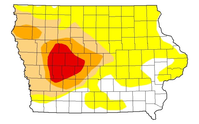
Weekly Drought Monitor Depicts First Extreme Drought Areas In Iowa
There remains no seriously drought concerns in the northwest Missouri region, and the drought coverage map for the week had an improved report for Missouri, but the a third level of drought severity has been reported in Iowa.
The US Drought Monitor map showed 66 percent of Missouri has no areas that are even considered Abnormally Dry, and only a couple of pocket in southwest Missouri are in a D1, or moderate drought, category.

Iowa’s situation is a much more serious situation. 80 percent of the state is considered to be in some degree of dryness. 34 percent of the state is now in Moderate Drought or worse. 16 percent of the state is considered to be in Serious Drought or worse. 6 percent of the state is considered to be in Extreme Drought, or in a D3 category. That area includes counties in the west central part of the state, generally between Des Moines and Council Bluffs. It is the first time this year that Extreme Drought areas have been included in the map. The southern tier of counties in Iowa are in the best shape. Northeastern Decatur and northern Wayne counties show some abnormally dry territory. The rest of the southern tier of Iowa counties within the region are not in a dryness category.